Location
The ancient city state of Aigeira is located at the Palaiokastro hill (means: old castle) at the north coast of the Peloponnese.
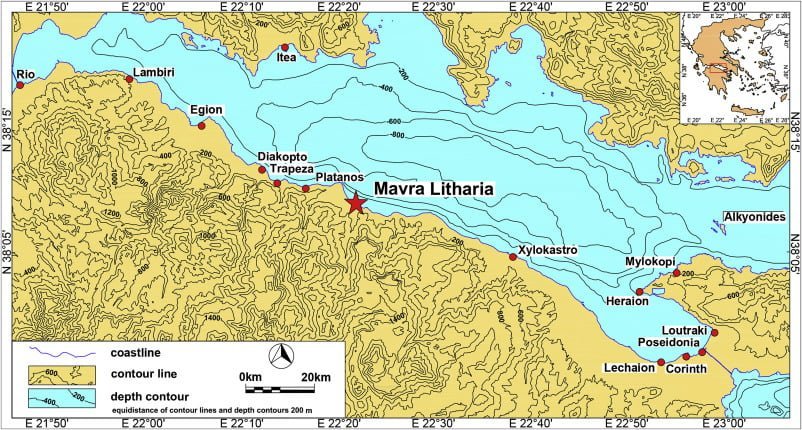
The harbour of ancient Aigeira was at the nook of Mavra Litharia (Black Rocks) settlement, at the foot of Palaiokastro hill, where its traces are observed, near the modern marina of Derveni, which administratively belongs nowadays.
The name of the settlement is referred to by foreign travelers and is due to the luminous dark-colored volumes that rise on the seaside near the harbor .
After World War I, there was a mine locally, from which they exported charcoal , coal and anthracite, which were loaded on ships from the port of Derveni to the European markets.

The natural cove offered good shelter against the prevailing NE and NW winds of the Corinthian Gulf.

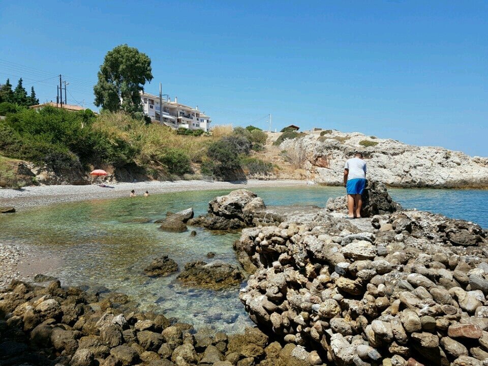
It is interesting that this region is one of the few on the coast of the northern Peloponnese that has the natural characteristics of a port (mostly sandy and straight with a few rocky areas that penetrate to the sea and is subjected to strong geological shoreline elevation phenomena and corrosion).
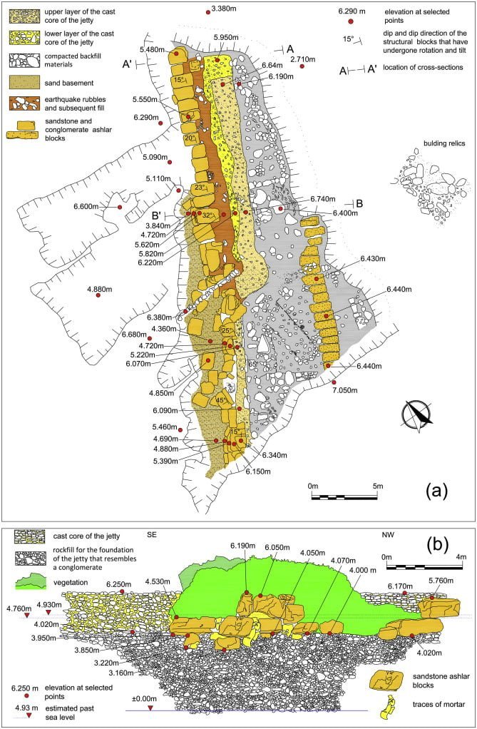
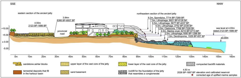
The port of ancient Aegira is open at the base of the hill of Palaiokastro, its remains stretching over an area of about 100m. along the coast and are better preserved in the eastern main section. Installations, debris and moles are now onshore. The coastline of the harbor construction is located at a height of about 4 meters, over the current surface of the sea.


E. Kolaiti et al. Quaternary International
Volume 508, 1 March 2019, Pages 23-35
History
The port of ancient Aegira is mentioned by Pausanias (VII, 26: 1-9) and by Polybios (IV, 57).
According to Pausanias , the port abstained 12 stadia* from the main Aigera (or Hyperasia as referenced by Homer), where with 6 ships and under the command of Agamemnon participated in the campaign against Troy.
*Stadia is an ancient greek unit of length measurement. It is equal to 600 ft or 184.9 m (202.2 yd).
Excavations in the city of ancient Aegira have been carried out by the Austrian Archaeological Institute since 1916. The remains of the ancient harbor were initially identified by W.Μ. Leake (1836: 386-387), but apart from individual references, they have not yet been the subject of systematic archaeological research. However, due to its great geological interest due to the high elevation of the coastline, it was studied by geologists and natural scientists.
Limenoscope – National Technical University of Athens
Topography
The topography of the ancient harbor of Aegira has unfortunately been significantly altered by geological factors, elevation and erosion of the coast, but mainly by anthropogenic factors, extensive building and glazing. Due to the great elevation of the coast, it was possible to interpret the stratigraphy of the harbor and to make observations about how it was constructed. Residues of two breakwaters or breakwaters and moles are being saved, extending northwards. Based on the winds prevailing in the region (NE and mainly NW) it is estimated that the breakwaters were constructed in a. NW and b. NE. The entrance of the harbor is located between the breakwater with the address NE and the rock that defines and protects the port from the west.
Construction
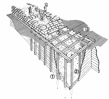
The structures were resting on the natural sand bottom. Their reef segment was formed from hydraulic mortar, rock pitches and stone fragments of the area in a wooden mold in the caissons technique. Above the sea surface, the structure consisted of large chipped stones placed on the outside and transversally at intervals, and filling the interior with cast material (opus cimentitium).
The port of ancient Aegira is a typical example of a Roman harbor as to the technique of construction with the extensive use of casting materials. The port was dated more accurately on the basis of data from the excavations of the remains of the ancient city. The construction of this quite expensive project is placed in the period of the 2nd century – the half of the 3rd century. AD, and perhaps around the reign of Emperor Maximus Thrace (236-238 AD). Also, based on the investigations made in the ancient theater, it was found that this was abandoned in 250 AD, when it was interrupted, without ever completing, its repair work. This fact as well as the abandonment of the harbor were attributed to geological studies in a large and devastating earthquake at the end of the 3rd century. A.D.
The conclusions that have so far been drawn for the topography and construction of the ancient harbor are based on observations made in its visible remains. The fact that no excavation has been carried out is a major obstacle to understanding and restoring the overall port plan. However, it remains a very important archaeological site as it is one of the few Roman harbors that survive in Greece and perhaps the only one that survives entirely onshore. It also offers a good subject of study on the impact that dramatic geological events may have on topography and the history of an area.

New insights into the uplifted Roman harbour at Mavra Litharia (N Peloponnese, Greece) in the geodynamic context of the southern margin of the Corinth Gulf
EleniKolaitiaNikosMourtzasbKonstantinosKissascfFabrizioAntoniolidKurtLambecke