Aigeira’s central location in the Greek mainland makes it an ideal place as an anchorage for sightseeing some of the top Greek cultural hotspots, as well as lesser known but worth discovering places of interest.
All the sites below are within 200 km and/or 2hrs drive from Aigeira.


Map of sightseeing locations and other points of interest within 200km and/or approx. 2hrs drive of Aigeira/Akrata.
Expand the map for a more detailed view.
“It is the most impressive of the acropolis of mainland Greece,” in the estimation of George Forrest. Acrocorinth was continuously occupied from archaic times to the early 19th century. Along with Demetrias and Chalcis, the Acrocorinth during the Hellenistic period formed one of the so-called “Fetters of Greece” – three fortresses garrisoned by the Macedonians to secure their control of the Greek city-states.
The city’s archaic acropolis, already an easily defensible position due to its geomorphology, was further heavily fortified during the Byzantine Empire as it became the seat of the strategos of the thema of Hellas and later of the Peloponnese. It was defended against the Crusaders for three years by Leo Sgouros.
Afterwards it became a fortress of the Frankish Principality of Achaea, the Venetians and the Ottoman Turks.[clarification needed] With its secure water supply, Acrocorinth’s fortress was used as the last line of defense in southern Greece because it commanded the Isthmus of Corinth, repelling foes from entry into the Peloponnese peninsula.
Three circuit walls formed the man-made defense of the hill. The highest peak on the site was home to a temple to Aphrodite which was converted to a church, and then became a mosque. The American School’s Corinth Excavations began excavations on it in 1929. Currently, Acrocorinth is one of the most important medieval castle sites of Greece.
In a Corinthian myth related in the 2nd century CE to Pausanias, Briareus, one of the Hecatonchires, was the arbitrator in a dispute between Poseidon and Helios, between the sea and the sun: his verdict was that the Isthmus of Corinth belonged to Poseidon and the acropolis of Corinth (Acrocorinth) to Helios.
The Upper Pirene spring is located within the encircling walls. “The spring, which is behind the temple, they say was the gift of Asopus to Sisyphus. The latter knew, so runs the legend, that Zeus had ravished Aegina, the daughter of Asopus, but refused to give information to the seeker before he had a spring given him on the Acrocorinth.”
For more information read the article here https://aigeira.org/history/
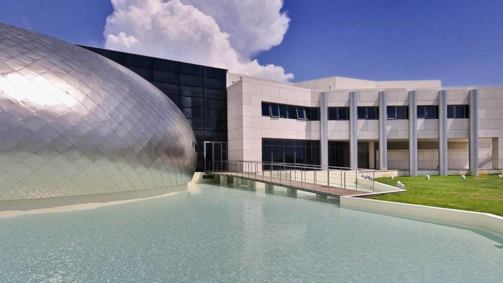
Thematically divided into units, the permanent collection is displayed in three imposing galleries allowing multiple views and good perspective of the exhibits. Exceptional, if not unique, about the Museum interior arrangement is the suspended / elevated passage, which allows overhead and overall view of two galleries. This smart and spectacular in terms of architectural design feature proves particularly useful during presentations and guided tours. More important, it allows ideal inspection of the enormous Roman mosaic floors, which define one of the Museum highlights.
Also outstanding is the building’s facade combining different materials (wood, metal, stone) in full harmony. Its geometry is equally groundbreaking, with a spherical dome of titanium above an artificial pool. In this way, the architect incorporated the element of water perhaps metaphorically alluding to the establishment of Patras by the sea – a strategic location with an impact upon the city s development over the centuries.
The Archaeological Museum of Patras was inaugurated in 2009. Its collections include finds from the broader district of Patras and Western Achaea, covering a wide chronological spectrum from 3000 BC until the 4th century AD. Via the exhibits, local population and students are encouraged to trace their ethnic identity and to familiarize themselves with local history but also with forms of art ranging from glassware to jewellery and mosaic.
Moreover, the richness of the Museum permanent collections, with periodical exhibitions on archaeology and visual arts running in parallel, efficiently meets the quests and research interests of specialized scholars. Within the Museum holdings are masterpieces of sculpture, which attract visitors from all over the world. In this respect, the Museum is very much alive, crossing regional cultural borders and constantly in interactive relation with society.
Beside the many programs attended frequently and massively by groups of school-children, the frequent periodical exhibitions, the lectures and seminars, the concerts and poetry evenings organized by the Ephorate of Antiquities of Achaea on a regular basis and any given occasion, render the Museum an active cultural centre, not only serving educational purposes but also in tune with the city’s pulse.
Overview
The site of Olympia, in a valley in the Peloponnesus, has been inhabited since prehistoric times. In the 10th century B.C., Olympia became a centre for the worship of Zeus. The Altis – the sanctuary to the gods – has one of the highest concentrations of masterpieces from the ancient Greek world. In addition to temples, there are the remains of all the sports structures erected for the Olympic Games, which were held in Olympia every four years beginning in 776 B.C.
Brief description
The sanctuary of Olympia, in the North West of the Peloponnese, in the Regional Unit of Eleia (Elis), has been established in the valley created by the confluence of the Alpheios and Kladeos rivers in a natural setting of beauty and serenity. The Pan-Hellenic sanctuary has been established in the history of culture, as the most important religious, political and sports centre, with a history that dates back to the end of the Neolithic times (4th millennium BC). The famous sanctuary became the centre of worship of Zeus, the father of the twelve Olympian gods.
For the Altis, the sacred grove and the centre of the sanctuary, some of the most remarkable works of art and technique have been created, constituting a milestone in the history of art. Great artists, such as Pheidias, have put their personal stamp of inspiration and creativity, offering unique artistic creations to the world. In this universal place, the Olympic Idea was born, making Olympia a unique universal symbol of peace and competition at the service of virtue. Here, too, prominence was given to the ideals of physical and mental harmony, of noble contest, of how to compete well, of the Sacred Truce; values, which remain unchanged in perpetuity.
The castle consists of a triangular outer enclosure reinforced with towers and bastions, which was originally protected by a deep moat and an inner enclosure rising on the NE angle and protected by a moat as well. The building phases distinguishable today on the castle provide evidence for the works carried out by each of its conquerors as repairs and provisions according to the development of military science. The original construction is visible today mainly along the north wall, but remains of it exist on all three sides of the curtain indicating that the original medieval fortification had more or less the same perimeter.
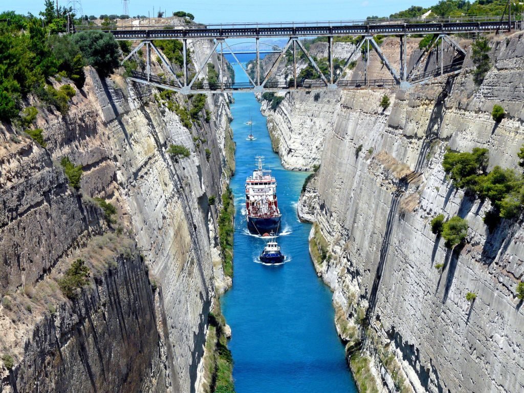
The canal was dug through the Isthmus at sea level and has no locks. It is 6.4 kilometres (4 mi) in length and only 21.4 metres (70 ft) wide at its base, making it impassable for most modern ships. Nowadays it has little economic importance and is mainly a tourist attraction.
The canal was initially proposed in classical times and a failed effort was made to build it in the 1st century AD. Construction started in 1881 but was hampered by geological and financial problems that bankrupted the original builders. It was completed in 1893 but, due to the canal’s narrowness, navigational problems and periodic closures to repair landslides from its steep walls, it failed to attract the level of traffic expected by its operators.
The port, with its watchtowers guarding the entrance, charms even the most demanding guests. Also its well preserved Venetian castle on the top of the hill is one of the most beautiful castles in Greece and a real gem for the city.
Nafpaktos is a city with lots of activity year round that increases during the summer. The visitor can find taverns, restaurants, cafés and bars in the city centre but also at the beaches nearby or on the hill of the castle that offers a view of the Corinthian Gulf.
It is named after Naupaktos (Ναύπακτος, Latinized Naupactus), an important Athenian naval station in the Peloponnesian war. As a strategically crucial possession controlling access to the Gulf of Corinth, Nafpaktos changed hands many times during the Crusades and the Ottoman–Venetian Wars. It was under Venetian control in the 15th century, and came to be known by the Venetian form of its name, Lepanto. It fell to the Ottoman Empire in 1499 and was used as naval station by the Ottoman Navy in the 16th century, being the site of the decisive victory by the Holy League in the Battle of Lepanto in 1571.
Miguel de Cervantes, the great Spanish writer and author of Don Quixote, fought in the Battle of Lepanto here and lost his left hand. He famously said that “The loss of my left arm, is for the greater glory of my right.”
The 2,380-metre-long (7,808 ft) bridge (approximately 1.8 miles) dramatically improves access to and from the Peloponnese, which could previously be reached only by ferry or via the isthmus of Corinth in the east. Its width is 28 m (92 ft) — it has two vehicle lanes per direction, an emergency lane and a pedestrian walkway. Its five-span four-pylon cable-stayed portion of length 2,252 m (7,388 ft) is the world’s third longest cable-stayed deck; only the decks of the Jiaxing-Shaoxing Sea Bridge in Shaoxing, China and the Millau Viaduct in southern France are longer at 2,680 m (8,793 ft) and 2,460 m (8,071 ft), respectively. However, as the latter is also supported by bearings at the pylons apart from cable stays, the Rio–Antirrio Bridge deck might be considered the longest cable-stayed “suspended” deck.
This bridge is widely considered to be an engineering masterpiece, owing to several solutions applied to span the difficult site. These difficulties include deep water, insecure materials for foundations, seismic activity, the probability of tsunamis, and the expansion of the Gulf of Corinth due to plate tectonics.
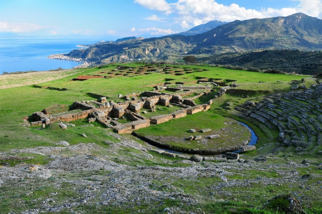
Originally, the Theatre had 34 rows of limestone seats, divided into 12 sections and it could seat about 6000 persons. It was extended in the 2nd c. BCE with the addition of 21 rows, divided into 22 sections, to double the original seating capacity.
The orchestra has a diameter of 20.30m and is encircled by a strip of marble. It is made of packed earth with a thymele (altar) in the center.
The two Parodoi to the left and the right of the skene (scene) provided access to the orchestra of the theatre. Only the foundations of the scene survive today, while the two Parodoi double stone door frames are modern restorations.
It combines an aesthetic harmony, arising from the regularity and mathematical proportion of its parts, with the excellent acoustics which allowed members of the audience in the uppermost tiers of seats to hear the slightest sound from the orchestra. The aesthetics and functionality of the theater had already been noted in antiquity. Pausanias praises the theater of Epidaurus for its symmetry and beauty, and attributes it to the architect Polykleitos.
The Acropolis of Athens and its monuments are universal symbols of the classical spirit and civilization and form the greatest architectural and artistic complex bequeathed by Greek Antiquity to the world.
In the second half of the fifth century bc, Athens, following the victory against the Persians and the establishment of democracy, took a leading position amongst the other city-states of the ancient world. In the age that followed, as thought and art flourished, an exceptional group of artists put into effect the ambitious plans of Athenian statesman Pericles and, under the inspired guidance of the sculptor Pheidias, transformed the rocky hill into a unique monument of thought and the arts.
The most important monuments were built during that time: the Parthenon, built by Ictinus, the Erechtheion, the Propylaea, the monumental entrance to the Acropolis, designed by Mnesicles and the small temple Athena Nike.
Brief description
The Acropolis of Athens is the most striking and complete ancient Greek monumental complex still existing in our times. It is situated on a hill of average height (156m) that rises in the basin of Athens. Its overall dimensions are approximately 170 by 350m. The hill is rocky and steep on all sides except for the western side, and has an extensive, nearly flat top.
Strong fortification walls have surrounded the summit of the Acropolis for more than 3,300 years. The first fortification wall was built during the 13th century BC, and surrounded the residence of the local Mycenaean ruler. In the 8th century BC, the Acropolis gradually acquired a religious character with the establishment of the cult of Athena, the city’s patron goddess.
The sanctuary reached its peak in the archaic period (mid-6th century to early 5th century BC). In the 5th century BC, the Athenians, empowered from their victory over the Persians, carried out an ambitious building programme under the leadership of the great statesman Pericles, comprising a large number of monuments including the Parthenon, the Erechtheion, the Propylaia and the temple of Athena Nike.
The monuments were developed by an exceptional group of architects (such as Iktinos, Kallikrates, Mnesikles) and sculptors (such as Pheidias, Alkamenes, Agorakritos), who transformed the rocky hill into a unique complex, which heralded the emergence of classical Greek thought and art.
On this hill were born Democracy, Philosophy, Theatre, Freedom of Expression and Speech, which provide to this day the intellectual and spiritual foundation for the contemporary world and its values. The Acropolis’ monuments, having survived for almost twenty-five centuries through wars, explosions, bombardments, fires, earthquakes, sackings, interventions and alterations, have adapted to different uses and the civilizations, myths and religions that flourished in Greece through time.
The small marble statue of Heraclea from Aigion, a Roman copy of the original work of 320-310 BC, is on display in the atrium with parts of architectural buildings, a funerary grave and inscriptions.
Room I: Findings of the Middle and Late Neolithic (windows 1-3) (6 to 4 millenium BC) and the EH period (Case 4) (3rd millennium BC) from the settlement of Krathi. They include pottery, clay figurines, loom weights and stone tools.
Room II: Here are the findings of the Middle Helladic (Case 5) (2nd millennium Amisus) and Late Helladic or Mycenaean period (1550-1060/40 BC) (windows 6-8). The Middle Helladic findings come from the town of Aigion and Krathio. The objects of the Mycenaean period have been found mainly in the investigation of the settlement and cemetery of the Aigion and the Aigeira, Trapeza and Achladia.
Room III: This room includes findings Protogeometric and Geometric period (late 10 th – 7th century BC) (windows 9-12). One important group comes from Derveni of Mamousia (Case 9), while special interest is an excellent set of funerary pithos which comes from Street Plastira in Aigion and includes four large bronze buckles and two Egyptian scarabs.
Room IV: In The Archaic (7th – 6th century BC.), Classical (5th – 4th century BC) and Hellenistic period (late 4th-1st century BC.) belong the findings of this gallery (windows 13 to 16). The Archaic period is represented in Aigion, the Mamousia, New Erineos, Kyrenia and Provod Kamares, and few are the findings of the classical period. Unlike the more developed Aigialeia occur during the Hellenistic period after the establishment of the Achaean confederacy. Important findings from the tombs of this period in Aigion and Mamousia include pottery and jewelry.
Room V: 17-18 On display are also presented findings of the late Hellenistic period, while the last two showcases ((19-20) exhibited objects of the Roman period (after 146 BC), which include pottery and glass vessels, and objects of bronze, ivory and clay.
In the last room of the museum (VI) exhibited the colossal statue of Zeus or young man with aigida (Aigiochos) of the first century. AD, which was found accidentally during excavation work for building in Aigion.
The pan-Hellenic sanctuary of Delphi, where the oracle of Apollo spoke, was the site of the omphalos, the ‘navel of the world’. Blending harmoniously with the superb landscape and charged with sacred meaning, Delphi in the 6th century B.C. was indeed the religious centre and symbol of unity of the ancient Greek world.
Brief Description
Delphi lies between two towering rocks of Mt. Parnassus, known as the Phaidriades (Shining) Rocks, in the Regional unit of Phocis in Central Greece. Here lies the Pan-Hellenic sanctuary of Apollo, the Olympian god of light, knowledge and harmony. The area was inhabited in the 2nd millennium BC, as is evident from Mycenaean remains (1500-1100 BC). The development of the sanctuary and oracle began in the 8th century BC, and their religious and political influence over the whole of Greece increased in the 6th century BC. At the same time, their fame and prestige spread throughout the whole of the then known world, from which pilgrims came to the site to receive an oracle from the Pythia, the priestess of Apollo. A place with a rich intangible heritage, Delphi was the centre of the world (omphalos) in the eyes of the ancient Greeks: according to myth, it was the meeting point of two eagles released by Zeus, one to the East and one in the West. The magnificent monumental complex is a human-made environment in perfect harmony with the rare natural environment, the principal features of which gave rise to the organisation of the cults. This harmonious relationship, which has remained undisturbed from ancient times to the present day, makes Delphi a unique monument and a priceless legacy bequeathed by the ancient Greek world to following generations.
The archaeological sites of Mycenae and Tiryns are the imposing ruins of the two greatest cities of the Mycenaean civilization, which dominated the eastern Mediterranean world from the 15th to the 12th century B.C. and played a vital role in the development of classical Greek culture. These two cities are indissolubly linked to the Homeric epics, the Iliad and the Odyssey , which have influenced European art and literature for more than three millennia.
Brief description
The Archaeological Sites of Mycenae and Tiryns, located in the Regional unit of Argolis in the North-East Peloponnese, are the imposing ruins of the two greatest cities of the Mycenaean civilization, renowned for its technical and artistic achievements but also its spiritual wealth, which spread around the Mediterranean world between 1600 and 1100 BC and played a vital role in the development of classical Greek culture. The palatial administrative system, the monumental architecture, the impressive artefacts and the first testimonies of Greek language, preserved on Linear B tablets, are unique elements of the Mycenaean culture; a culture that inspired the great poet Homer to compose his famous epic poems.
The citadel of Mycenae, with its strategic position for the control of the Argolid Plain, is the kingdom of the mythical Agamemnon and the most important and richest palatial centre of the Late Bronze Age in Greece. Its name was given to one of the greatest civilizations of Greek prehistory, the Mycenaean civilization, while the myths related to its history, its rulers and their family members (such as Klytaimnestra, Ifigeneia, Elektra, Orestes) have inspired poets, writers and artists over many centuries, from the ancient to the contemporary times. Significant stages in monumental architecture are still visible in the property, such as the massive defensive walls, the corbelled tholos tombs and the Lions Gate.
Tiryns, situated 20 km north-east of Mycenae on a low hill near the inlet of the Argolic Gulf, is another excellent example of the Mycenaean civilization. The fortification of the hill, completed at the end of the 13th century BC, surrounds the citadel with a total perimeter of approximately 750 m. The impressive walls, built of stones even larger than those of Mycenae, are up to 8 m thick and 13 m high. They can rightly be regarded as a creation that goes beyond the human scale, as reveals the word “cyclopean” – built by Cyclops, the mythical giants from Lycia – which was attributed to them in the Homeric epics.
It was formerly known as Troupisio.
The cave is an old subterranean river consisting of three levels. During the winter when the snow melts it is transformed into a flowing river with waterfalls. During the summer, it dries up, leaving behind 13 lakes.
It is mentioned in the writings of the ancient traveller Pausanias.
According to Greek legend, it was in this cave that Melampus cured the two of the three daughters of Proetus, king of Tiryns, Lysippe and Iphianassa. The third daughter, Iphinoe, had died on the way.
Humans started using the cave during the Neolithic Age. It was in continued use throughout the duration of the Bronze Age.
It presents significant paleontological and archaeological interests. On the lower level of the cave were found fossilized human bones and various animals including hippopotamus.
The monastery is located in a large cave in a sheer cliff, where the western slopes of Mount Chelmos drop down to the gorge of the Vouraikos river, some 11 kilometres (6.8 mi) northwest of the town of Kalavryta. The cave was known in antiquity, and the geographer Pausanias reports that the daughters of Proetus found refuge there during their madness. In the first Christian centuries, Christian hermits occupied the cave.
According to tradition, the monastery is one of the oldest in Greece, reputedly founded in 362 by the Thessalonian brothers Symeon and Theodore, who with the help of Euphrosyne (a local shepherdess, honoured as saint for her part in these events) discovered in the cave the icon of the Theotokos painted by Luke the Evangelist.
Its medieval history under Byzantine and Latin rule is obscure. The monastery gained prominence only from about 1354, when it served as the residence of the Orthodox Metropolitan of Patras, since the city was still occupied by the Latins and the seat of a Latin archbishopric. The complex suffered large-scale destructions in 849, 1400, and 1640, when it was comprehensively rebuilt.
Several of the monks became members of the Filiki Etaireia and took part in the Greek War of Independence. In 1934, the katholikon was destroyed in a fire, and replaced by a new church in 1937. On 8 December 1943, the German 117th Jäger Division destroyed the monastery and executed 22 monks and visitors as part of reprisals that culminated a few days later with the Massacre of Kalavryta.
The monastery was rebuilt from the ground after the war, and now comprises an eight-storey complex set in the 120 metres (390 ft) high cliff face. A male monastery, it celebrates on 15 August (the day of the Dormition), 14 September, and 18 October (Luke the Evangelist and the ktetors).
The Odeum of Patra was severely destroyed by successive invasions, wars, and earthquakes. It was almost buried under the remains of other buildings and ground. It was in 1889 when the Odeum was found by accident while some workers were digging up the ground for the construction of the port. The restoration of the Odeum continued till 1956 when it regained its original shape. Along with its restoration process, the nearby areas were declared as archaeological sites.
The Roman Odeum today functions as the chief venue for Patras International Festival held every summer and other cultural events. The Odeum has a seating capacity of 2,300 people with all the basic facilities of a theatre such as hollow, orchestra, proscenium, scene and wings.
This is a landscape worthy of the myth. We can enjoy the view of the frightening rock with its waterfall (with just a little water today), with the Krathis Gorge and the Tessera Elata in the background.
Due to carbonised iron/mineral deposits on the vertical slope of the mountain giving it it’s distinct black appearance, the waterfall is called Mavroneri (black water).
